Izmir (İzmir)
İzmir, also spelled Izmir, is a metropolitan city in the western extremity of Anatolia, capital of the province of the same name. It is the third most populous city in Turkey, after Istanbul and Ankara and the second largest urban agglomeration on the Aegean Sea after Athens.
As of the last estimation, on 31 December 2019, the city of İzmir had a population of 2,965,900, while İzmir Province had a total population of 4,367,251. Its built-up (or metro) area was home to 3,209,179 inhabitants extending on 9 out of 11 urban districts (all but Urla and Guzelbahce not yet agglomerated) plus Menemen and Menderes largely conurbated. It extends along the outlying waters of the Gulf of İzmir and inland to the north across the Gediz River Delta; to the east along an alluvial plain created by several small streams; and to slightly more rugged terrain in the south.
İzmir has more than 3,000 years of recorded urban history, and up to 8,500 years of history as a human settlement since the Neolithic period. In classical antiquity the city was known as Smyrna – a name which remained in use in English and various other languages until around 1930, when government efforts led the original Greek name to be gradually phased out internationally in favor of its Turkish counterpart İzmir. Lying on an advantageous location at the head of a gulf running down in a deep indentation, midway along the western Anatolian coast, İzmir has been one of the principal mercantile cities of the Mediterranean Sea for much of its history. It hosted the Mediterranean Games in 1971 and the World University Games (Universiade) in 2005. The city participated in Climathon in 2019.
İzmir has over 3000 years of recorded urban history and up to 8500 years of history as a human settlement since the Neolithic period. Set in an advantageous location at the head of a gulf in a deep indentation midway along the western Anatolian coast, the city has been one of the principal mercantile ports of the Mediterranean Sea for much of its history. Modern İzmir also incorporates the nearby ancient cities of Ephesus, Pergamon, Sardis and Klazomenai, and centers of international tourism such as Kuşadası, Çeşme, Mordoğan and Foça. When the Ottomans took over İzmir in the 15th century, they did not inherit compelling historical memories, unlike the other key points of the Ottoman trade network, namely Constantinople (Istanbul), Damascus, Baghdad and Cairo.
The emergence of İzmir as a major international port by the 17th century was largely a result of the attraction it exercised over foreigners and the city's European orientation. Politically, İzmir is considered a stronghold of Kemalism and the Republican People's Party (CHP).
Izmir's port is Turkey's primary port for exports in terms of the freight handled and its free zone, a Turkish-U.S. joint-venture established in 1990, is the leader among the twenty in Turkey. The workforce, and particularly its rising class of young professionals, is concentrated either in the city or in its immediate vicinity (such as in Manisa and Turgutlu), and as either larger companies or SMEs, affirm their names with an increasingly wider global scale and intensity.
İzmir hosted the Mediterranean Games in 1971 and the World University Games (Universiade) in 2005. In March 2008, İzmir submitted its bid to the BIE for hosting the Universal Expo 2015, but it was won by Milan, Italy.
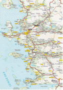
Map - Izmir (İzmir)
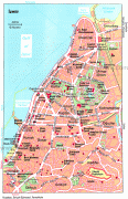
Map


Country - Turkey
 |
|
| Flag of Turkey | |
One of the world's earliest permanently settled regions, present-day Turkey was home to important Neolithic sites like Göbekli Tepe, and was inhabited by ancient civilisations including the Hattians, Hittites, Anatolian peoples, Mycenaean Greeks, Persians and others. Following the conquests of Alexander the Great which started the Hellenistic period, most of the ancient regions in modern Turkey were culturally Hellenised, which continued during the Byzantine era. The Seljuk Turks began migrating in the 11th century, and the Sultanate of Rum ruled Anatolia until the Mongol invasion in 1243, when it disintegrated into small Turkish principalities. Beginning in the late 13th century, the Ottomans united the principalities and conquered the Balkans, and the Turkification of Anatolia increased during the Ottoman period. After Mehmed II conquered Constantinople (Istanbul) in 1453, Ottoman expansion continued under Selim I. During the reign of Suleiman the Magnificent, the Ottoman Empire became a global power. From the late 18th century onwards, the empire's power declined with a gradual loss of territories. Mahmud II started a period of modernisation in the early 19th century. The Young Turk Revolution of 1908 restricted the authority of the Sultan and restored the Ottoman Parliament after a 30-year suspension, ushering the empire into a multi-party period. The 1913 coup d'état put the country under the control of the Three Pashas, who facilitated the Empire's entry into World War I as part of the Central Powers in 1914. During the war, the Ottoman government committed genocides against its Armenian, Greek and Assyrian subjects. After its defeat in the war, the Ottoman Empire was partitioned.
Currency / Language
| ISO | Currency | Symbol | Significant figures |
|---|---|---|---|
| TRY | Turkish lira | ₺ | 2 |
| ISO | Language |
|---|---|
| AV | Avar language |
| AZ | Azerbaijani language |
| KU | Kurdish language |
| TR | Turkish language |